Peace Street in Whakatāne is undergoing major road and infrastructure works as important upgrades are rolled out.
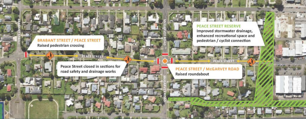
While the road is a key connecting link to the CBD, there are issues with Peace Streets’ busy four-way intersection with McGarvey Road, lack of safe crossings points, and stormwater drainage issues.
The improvement project aims to reduce instances of flooding after heavy rain, and increase safety of all road users travelling through the area. Strengthening stormwater infrastructure in the Peace Street area will be a two-pronged approach:
- Wider, deeper kerbside channels will be constructed along Peace Street to improve surface water drainage on the road, with improved gradients so water flows better also. These channels will also connect into the Peace Street Reserve to take more water off the road surface.
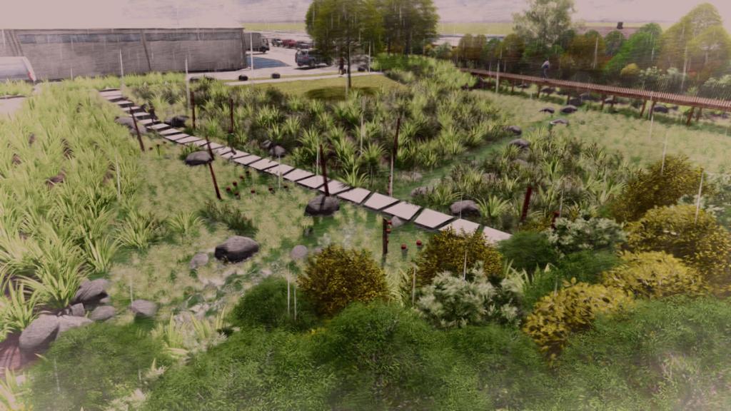
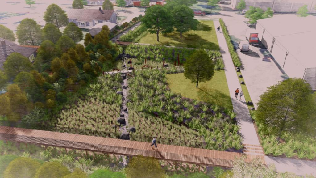
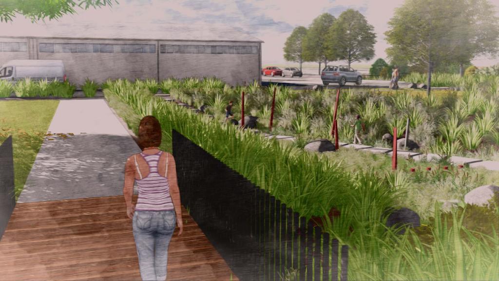
- In a progressive move toward more sustainable stormwater management, Peace Street Reserve will be transformed in to Whakatāne District’s first official ‘sponge reserve’. This is a wetland designed to absorb and filter rainwater, helping to reduce the risk of flooding and pollution in nearby water bodies while replenishing groundwater.
In addition to the stormwater upgrade, work to improve road user safety in the area will also occur and includes:
- The Peace Street / McGarvey Road intersection will be upgraded to a roundabout.
- A raised pedestrian crossing will be installed between Peace Street and Brabant Street.
- A shared-use pathway connecting McAlister Street and McGarvey Road - (Please note, this component of the project has been paused)
Road works are expected to be completed by 19 July 2024 (weather dependant). The transformation of Peace Street Park in to a sponge reserve is expected to be completed by August, with planting to commence following the completion of construction works. Residents and motorists are advised to expect closures to sections of Peace Street and temporary disruption to off-street parking during this time. Access will be maintained for residents.
More Information
Map of road closures 17 June - 19 July 2024 »
Frequently Asked Questions
- What is happening?
Peace Street in Whakatāne is undergoing major road and infrastructure works as important upgrades are rolled out.
The improvement project will enable key safety issues with Peace Street’s busy four-way intersection with McGarvey Road to be addressed. The intersection, which serves as a key connecting link to the CBD, lacks safe crossings points, and experiences stormwater drainage issues after heavy rain.
The project aims to reduce instances of flooding, and increase safety of all road users and pedestrians travelling through the area.
Strengthening stormwater infrastructure in the Peace Street area will be a two-pronged approach:- Wider, deeper kerbside channels will be constructed along Peace Street to improve surface water drainage on the road, with improved gradients so water flows better also. These channels will also connect into the Peace Street Reserve to take more water off the road surface.
- In a progressive move toward more sustainable stormwater management, Peace Street Reserve will be transformed in to Whakatāne District’s first official ‘sponge reserve’. This is a wetland designed to absorb and filter rainwater, helping to reduce the risk of flooding and pollution in nearby water bodies while replenishing groundwater.
In addition to the stormwater upgrade, work to improve road user safety in the area will also occur and includes:
- The Peace Street / McGarvey Road intersection will be upgraded to a roundabout.
- A raised pedestrian crossing will be installed on Peace Street, off the Brabant Street intersection.
- A shared-use pathway connecting McAlister Street and McGarvey Road (Please note, this component of the project has been paused).
- Why are we doing this?
To improve stormwater management by:
- installing wider, deeper kerbside channels and improving gradients along Peace Street so water flows better. These kerbside channels will also connect into Peace Street Stormwater Reserve to take more water off the road surface
- optimising the catchment from a stormwater perspective by minimising the rate of pumping and maximize flood storage volumes. Overall, this will help manage stormwater flood effects by providing safer areas for stormwater to pond during heavy rainfall events
- providing a space that is resilient to the effects of climate change, in particular, sea level rise (rising groundwater)
To improve road user safety by:
- upgrading the Peace Street / McGarvey Road intersection to a roundabout to reduce crash rate and severity due to the slowing of traffic on Peace Street
- providing safe pedestrian access between Peace Street and Brabant Street
- providing safe parking options
- forming a pedestrian and/or cycling conenction through the area via the drainage reserve between McAlister Street and McGarvey Road to improve connectivity in the area
In addition, the Peace Street sponge reserve project will provide additional benefits such as:
- providing an enhanced open recreational space for our communities with improved features and improved connectivity for pedestrians and cyclists
- promoting biodiversity by creating naturalised stream channels and a ‘sponge reserve’ which will provide habitat for wildlife.
- When is this happening?
October 2023 – August 2024. Road works will be completed and all roads re-opened by 19 July 2024 (weather dependant).
- Why has this design been chosen for Peace Street Park?
The concept to improve the stormwater function of the Peace Street Reserve has been in development for quite some time. The design was chosen to meet a variety of community needs, including recreation, environmental sustainability, and stormwater/flood management. It aims to strike a balance between these elements to create a vibrant yet functional stormwater reserve.
This particular design is known as a ‘sponge reserve’, and once completed, Peace Street Park will be Whakatāne District’s first official sponge reserve.
The design is consistent with modern stormwater practices that seek naturalised systems to manage the effects of stormwater. The benefits of such systems were observed during the recent Auckland floods and referred to by some media as ‘Sponge Cities’.
The concept of Sponge Cities improves water resource management through innovative measures such as 'daylighting' streams, reducing impervious surfaces, enhancing green spaces, and implementing green infrastructure. This type of stormwater design is now standard in many new developments across the country and is sometimes referred to as Low Impact Urban Stormwater Design or Water Sensitive Urban Design.
The design also includes green spaces, native planting, walking paths, seated areas and features like wetland areas and open channels for enhanced stormwater management and biodiversity.
- What is a ‘sponge reserve’?
A 'sponge reserve' is an environmentally sustainable approach to stormwater management. It’s essentially a wetland designed to absorb and filter rainwater, helping to reduce the risk of flooding and pollution in nearby water bodies while replenishing groundwater.
- What are the environmental benefits of this design?
Ecological and landscaping consultants have been part of the design team to develop solutions that maximise ecological benefits. In part, this will be achieved by ensuring suitable native plant species are selected that will be appropriate for the level of salinity anticipated. The design of the proposed flood storage area will involve creation of stream-like habitat, planting of riparian margins with appropriate indigenous species. Planting of the riparian margins and wet areas, where water may pool, with suitable indigenous species will increase biodiversity in an area which is otherwise mainly dominated by exotic amenity species.
- Will these improvements prevent Peace Street and surrounding areas from flooding?
The Peace Street sponge reserve will provide additional catchment storage of almost 4,000m3. This will provide some relief to private property owners and road users as this is the volume of water that would otherwise pond on the road or private property. This water will then drain through the existing stormwater infrastructure.
- Isn't the Peace Street Reserve area already a drainage reserve?
Yes, the area has historically served as a drainage reserve. However, the project will enhance its functionality by incorporating sustainable stormwater management practices and recreational features. Historically, before the Whakatāne River was stop banked, this part of Whakatāne was an extensive wetland. In some ways, transforming Peace Street Park into a sponge reserve will return to its natural state but operate much more effectively in managing stormwater.
- How will the bird and aquatic life (tuna/eels) in this existing area be looked after?
The project includes measures to protect and enhance the local ecosystem. Wetland areas and appropriate habitats will be created to support bird and aquatic life. Environmental experts will monitor and manage these aspects to ensure the well-being of the local fauna.
- Will any additional parking be created near the park for the CBD?
There will be no additional parking created as the Peace Street reserve project aims to improve pedestrian access and utilisation of the reserve for recreational activities. However, as part of the road safety improvements in the area additional parking will be included near the Peace Street dairy.
- How much is this going to cost?
The overall cost of this project is $3.4M
- Peace Street road safety and drainage improvements = $2.2M (As with most of our transport projects, Waka Kotahi are co-funding 63% of this project. Of the $2.2M roading works, $814K is funded from Council and $1,386K from Waka Kotahi.)
- Peace Street Park urban transformation / sponge reserve = $1.2M (funded through Whakatāne Stormwater capital expenditure)
- How is this being funded?
This work is funded as projects identified in the current Long Term Plan. The Peace Street Park work is funded through Whakatāne Stormwater capital expenditure. This work is funded as projects identified in the current Long Term Plan. The Peace Street Park work is funded through Whakatāne Stormwater capital expenditure. As with most of our transport projects, Waka Kotahi are co-funding 63% of the roading component of this project. Of the $2.2M roading works, $814K is funded from Council and $1,386K from Waka Kotahi.
We’re rolling out three Long Term Plan projects in the same area at the same time to minimise disruption to residents and motorists.
These projects include the 3 Waters Peace Street Park urban transformation / sponge reserve project, Transportation’s drainage improvements project on Peace Street, and a Waka Kotahi ‘Road to Zero’ road safety project on Peace Street and through the McAlister/McGarvey Road area.
- Why are you doing this now when we already have other road works disrupting town?
Roading works upgrades and earthworks across the district have a limited construction season, usually during late Spring and Summer due to lower rainfall figures. It's very tricky to do the work we need to do when there's bad weather. We’ve combined three Long Term Plan projects in the same area together to minimise disruption to residents and motorists.
- What disruption to traffic will there be?
Sections of Peace Street will be closed to the general public as we move through the various phases of the project. Detours will be in and well signposted.
From Monday 17 June the last phase of the road works component of this project starts. This involves the construction of a roundabout, raised pedestrian crossings, footpath, and drainage works at the current Peace Street / McGarvey Road intersection - near the dairy.
Temporary road closures and detours will be in place in the neighbourhood for approximately five weeks while we complete this work.
Peace Street will be closed entirely from Brabant Street to Peace Street Service Lane, with resident access only. McGarvey Road will be partially closed with resident access only from Sullivan Street to Peace Street, and from Pohutu Street to Peace Street.
- Will pedestrians still be able to access Peace Street?
Footpaths will be open during all construction works.
- Will Peace Street be closed over Christmas?
No. We will break from construction over the Christmas period. We will break from 23 December and recommence work on 8 January.
- What are the hours and days of work?
The works will take place Mondays to Friday from 7am to 6pm. On occasion we will also work Saturdays 8am to 6pm.
- I live nearby, how will construction affect my property?
The impact on nearby properties is carefully considered during the planning and construction phases. Any potential disruptions will be managed as effectively as possible to minimise inconvenience to residents. Residents will be regularly communicated with via letters, social media and website updates and alternatively can call our Customer Service team on 07 306 0500 for any queries that aren’t covered in these FAQs.
- Will the reserve area be lit at night?
Parts of the walkway will feature low level positioned lighting that is designed for illuminating walkways to meet safety requirements while not creating light pollution for neighbouring properties.
- Will the sponge reserve area be prone to mosquitos?
The good news, the sponge reserve project should see a reduction in stagnant water which should reduce breeding grounds for mosquitoes. However, as with any green space, the presence of some mosquitoes is still possible. Regular maintenance and environmental considerations will help manage this issue.
- Are you working with iwi on this?
Yes, our planning team are managing iwi engagement as part of the resource consent process, a copy of the draft consent with design details has been provided and our planning team are in the process of arranging a site visit to walk through the proposed works. We will also be working with iwi on the potential renaming of the reserve once works are completed.
- Will you use mātauranga Māori to choose what plants you put in the area?
An ecologist has provided professional advice regarding indigenous plant species and restoration planting for the project together with site preparation and planting phasing. Iwi will be given the opportunity to provide input on a proposed planting plan (this not yet underway).
- What happens if my driveway is damaged during this kerb and channel work?
The nature of this work will mean some driveways will need to be reconstructed due to gradient changes. Not all driveways along this section will be replaced.
- Why are you putting another roundabout in?
The new roundabout at the Peace Street / McGarvey Road intersection will be more effective at reducing crash occurrence as they are a safer intersection option for crossroads. The roundabout will be safer and more effective at accommodating crossing and turning traffic.
The roundabout development is part of the Waka Kotahi NZ Transport Agency ‘Road To Zero’ programme, and also feeds in to the Active Whakatāne programme, improving safety and access for alternate transport modes.
Tēnā koutou I manawanui mai – Thank you for your patience.