The Whakatāne District Climate Change Risk Assessment (a project which forms part of the Council’s wider adaptation work) has been completed and was presented to the Environment, Energy and Resilience Committee on 7 August 2025.
The report brings together local knowledge, iwi and hapū input and technical analysis to show where flooding, landslides, coastal erosion, sea level rise, extreme heat, drought and fire could affect people, places and services now and over time.
The assessment looks at the risks, limits, and uncertainties we face. It's not property-specific and it doesn’t recommend particular solutions. Instead, it helps guide what adaptation planning and emergency planning we focus on, where upgrades are needed, and how we shape future plans.
This work supports Our Climate Pathway and the 2024–34 Long Term Plan and aligns with regional efforts by Toi Moana Bay of Plenty Regional Council and Bay of Plenty Civil Defence.
The Adaptation Explorer
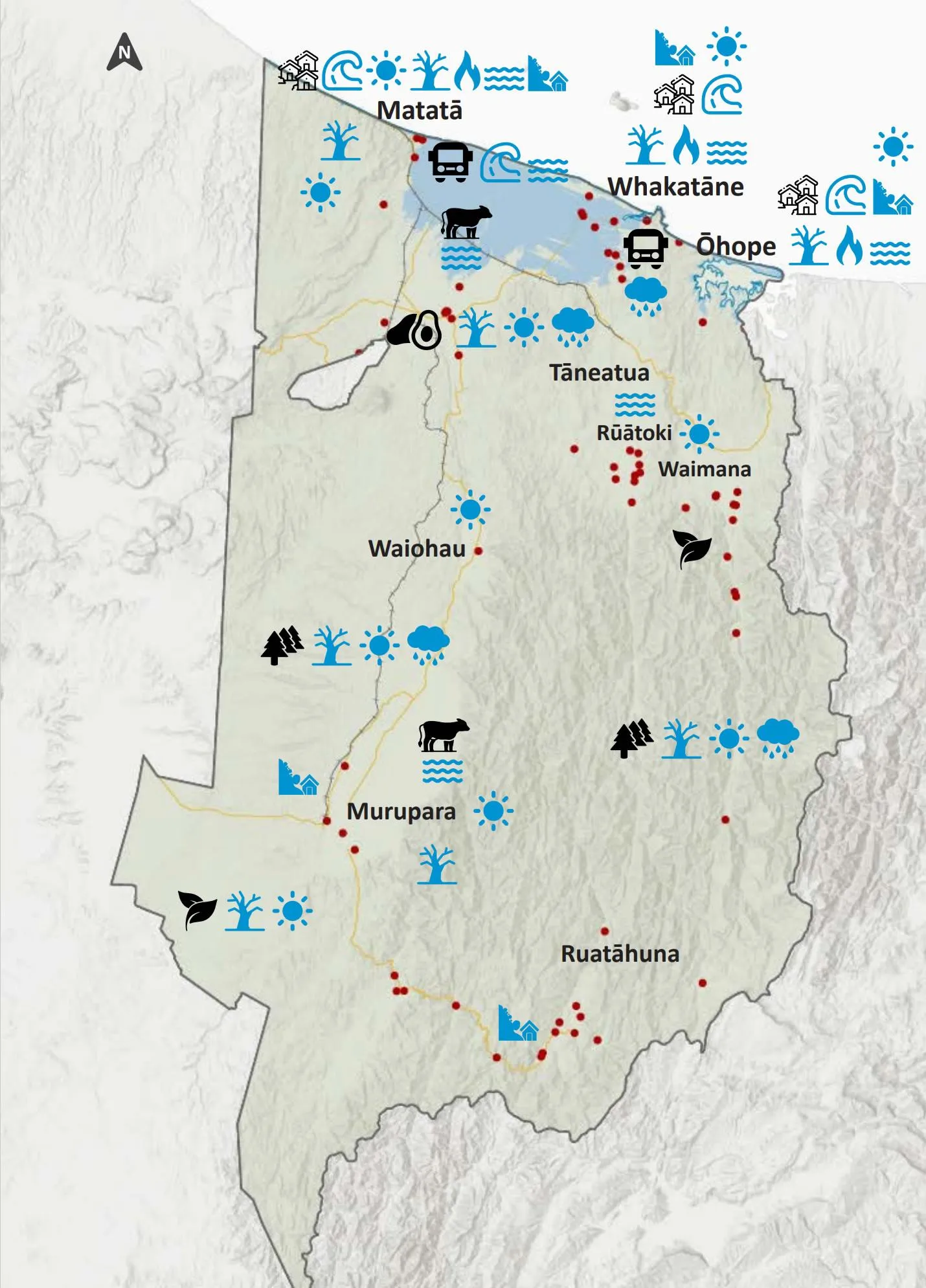
The Adaptation Explorer is an online, interactive map that shows climate-related hazards and climate risk information across the district. It's designed to make information easier to access and understand so individuals, communities, businesses and Council can plan for resilience.
Important to know before you use it
The Adaptation Explorer provides an overview, not exact answers.
- The maps show general climate-related hazard areas, not risk for each individual property
- Climate modelling shows possibilities, not exact predictions
- The maps do not include future infrastructure upgrades or protection works that may happen
- For property-specific advice, you should speak with a qualified expert such as a planner, engineer or other professional
Council cannot give insurance or property value advice. Please contact your insurer or valuer directly for guidance.
Launch the Whakatāne Adaptation Explorer »
Learn more
If you have questions, our FAQs explain what the Climate Change Risk Assessment is, what the Adaptation Explorer shows, how climate-related hazard mapping works and what this may mean for LIMs and insurance. If you have any other questions, contact resilience@whakatane.govt.nz
2026 Workshops
The project team are also holding three workshops where you can learn more about how to use the Adaptation Explorer.
When: Tuesday 31 March, Tuesday 14th April and Tuesday 28 April
Time: 10am-12pm
Where: Whakatāne District Council, Pohutakawa Room
Read the full report below
Detailed Risk Assessment Workbook
The Detailed Risk Assessment Workbook covers the detailed technical analysis supporting the Whakatane District Climate Change Risk Assessment report and should be read in combination with the report.
*This report has been prepared by Tonkin and Taylor for the Whakatāne District Council Environment Energy and Resilience Committee. Whakatāne District Council does not accept any responsibility or liability for any direct, indirect, incidental, consequential, special, exemplary or punitive damages or for any loss of profit, income or any intangible losses or any claims, costs, expenses or damages, whether in contract, tort (including negligence), equity or otherwise, arising directly or indirectly from or connected with the use of this report. This report summarises work undertaken for the Whakatāne District Council Environment Energy and Resilience Committee and does not constitute Council policy. If excerpts or inferences are drawn from this document for further use by individuals or organisations, due care should be taken to ensure that the appropriate context has been preserved and is accurately reflected and referenced in any subsequent spoken or written communication. Whakatāne District Council has exercised all reasonable skill and care in preparing this report but does not accept liability for the use of this information by any other party.
FAQs - understanding climate change risks in the Whakatāne District
The Whakatāne District is already experiencing the impacts of climate change, and we know the risks will increase over time. The Whakatāne District Climate Change Risk Assessment (CCRA) is a key step to help us plan and protect people, places, and infrastructure from future climate events.
- What is the Climate Change Risk Assessment (CCRA)?
It’s a report that identifies the most significant climate-related risks in the Whakatāne District - now and into the future. It combines the latest science, local knowledge, hazard data, and community input.
- Why did the Council do this assessment?
We want Whakatāne to stay a safe and thriving place to live. The assessment helps us understand what climate change could mean for our homes, roads, businesses and environment. By knowing the risks early, we can make better decisions, avoid future costs and keep our communities safe.
- What kind of risks are included?
The assessment looks at risks from flooding, landslides, coastal erosion, sea level rise, extreme heat, drought, and fire, across both the environment and built assets like roads, stormwater, and wastewater.
- Who was involved in the process?
More than 800 people contributed through workshops, community events, iwi and hapū engagement, and sector-specific conversations. This has been a collaborative effort - a partnership across different parts of the Council, iwi and the community. We all have a part to play in adapting to climate change.
- Is this a one-off report?
No. The assessment will be updated over time as new data becomes available and as we continue community conversations.
- Why are we talking about climate risks now?
We're not introducing new risks. We’re helping to better understand the ones already here and how they might impact us in the future. As the climate changes, it's important we get ahead of the curve and start planning now.
- What are examples of adaptation actions from risk assessments?
The assessment doesn't just identify risks, it also helps us plan how to reduce them. Examples of adaptation actions include:
- Upgrading stormwater systems so they can cope with heavier rain
- Raising roads or other infrastructure in low-lying areas
- Shifting farming practices to suit changing conditions
- Using a mix of energy sources so we’re not reliant on just one
- Updating planning rules to keep new buildings safer (for example, setting minimum floor levels in flood-prone areas, or avoiding development in high-risk zones)
- Informing individual and community evacuation plans
- How can businesses benefit from the CCRA?
The proposed National Adaptation Framework recognises the broad social, cultural, financial, and environmental benefits associated with investing in resilience measures before events happen.
The CCRA provides a lot of information that businesses can use beneficially to be more resilient. Embedding climate change considerations in decision-making will contribute to realising benefits to businesses that include: identifying new markets or products, reducing insurance costs, avoiding supply chain disruptions, protecting brand reputation, and meeting investor expectations.
- How does the CCRA fit in with the Government's direction on climate change?
The Government recently announced a proposed National Adaptation Framework to help ensure New Zealand’s infrastructure is resilient and communities are well prepared for the adverse effects of climate change. It sets out the Government's approach for an enduring system that prepares Aotearoa New Zealand for climate change, supports economic growth and keeps the costs to NZ as low as possible. In this latter regard, the framework sends a strong Government signal of a shift towards “a state where the Crown no longer distorts risk signals and blunts incentives to manage risk by providing significant financial assistance (especially in the form of residential property buyouts) after major events.
The CCRA supports Government policy direction by improving the ways information about climate risks is shared. In a national policy setting aimed at increasing property owner responsibility for climate change impacts, the CCRA provides property owners and businesses with information to be able to plan and implement responses to risks now that reduce those impacts. The CCRA also provides information that enables identification and investment in opportunities that climate change will enable.
Latest news
Understanding climate change risks in the Whakatāne District
New online tool helps Whakatāne District communities understand climate risks
Why is a climate change risk assessment for the region important?
A district climate change risk assessment will provide us all with a specific understanding of climate risks and assist our collective district and regional responses to make our communities more resilient to climate change.
It will also:
- identify and highlight areas within our district where efforts to manage climate effects need to be focused
- identify opportunities a changing climate could bring
- identify gaps in our understanding
- inform adaptation planning at a range of scale and by a range of parties, and build on existing adaptation planning projects in the district and region
- support the development of Local Adaptation Plans for individual communities
- help identify targeted action and further projects.
General climate change projections for the Whakatāne District
The following information from the Bay of Plenty Regional Climate Change Risk Assessment can be used as a guide to identifying climate risks within the Whakatāne District. Over the next century, we can expect:
- Rising sea levels and coastal flooding
- Rising ground water levels
- More extreme weather (including heavier rainfall during extreme events)
- Warmer summers including significantly more hot days (>25oC) and more very hot days (>30oC)
- Milder winters with less frost days especially in inland areas
- While overall rainfall during a year is predicted to remain similar to present rainfall, the rainfall will likely be more concentrated around the winter period, more intense when it does occur, and potentially lead to more severe flooding
- Drought and fire risk will increase especially in the upper Rangitāiki and Tarawera catchments
- Ocean warming and acidification
 Marae locations
  State Highway
  Railway
  River and surface flooding
  Coastal Flooding