Submissions for the Proposed Plan Change are now closed.
More on Proposed Plan Change 1 submissions »
Background
In May 2005, extremely heavy rainfall in the steep catchments behind Matatā caused a number of debris flows, which devastated much of the coastal township. A total of 27 homes were destroyed, 87 other properties were damaged, and major transport links were cut, resulting in an estimated $20 million in damage.
The most destructive debris flow – from the Awatarariki Stream, at the western end of Matatā – saw an estimated 300,000 cubic metres of rock, wooden debris and mud flow through the urban area at the base of the catchment. While there were no deaths or injuries, the destructive force of this natural hazard was such that it could easily have had a tragic outcome.
An investigation into the causes of the debris flows in 2005 by GNS Science confirmed they were natural events triggered by exceptionally heavy rain. GNS also confirmed that there was evidence that other, and larger debris flows have occurred over the last 7,000 years; and that historical records indicate that four smaller debris flows may have occurred since 1860.
Between 2005 and 2012, the Whakatāne District Council investigated possible engineering options (including a debris dam and a ring net structure) to mitigate the risk from future debris flows in the Awatarariki Stream catchment. Expert engineering advice subsequently confirmed that there is no viable engineering solution to manage this risk.
From 2013, the Council has focused on reducing the life safety risk for people living on the fanhead area through a planning approach. This has involved an assessment of the risk and investigations of non-engineering options (including the provision of early warning systems and proactive catchment management) that might reduce the risk to residents. The assessment of risk concluded that part of the fanhead presents a high fatality risk to residents, which makes residential use of that area unsafe. The investigations of non-engineering options concluded that there was no alternative option available that would effectively address the risk posed by debris flows.
In the absence of any viable risk reduction options, the Council has initiated plan change processes, under the Resource Management Act 1991, which aim to address the high loss-of-life risk by preventing future development and removing ‘existing use’ rights for residential properties on the fanhead.
Alongside the plan change processes, the Council has prepared a business case and acquisition strategy to support a managed retreat from the high risk area on the Awatarariki fanhead, which would enable property owners to sell their properties at market value, without any discount for the hazard. The managed retreat proposal is reliant on funding support from the Government and Regional Council and the Council is actively pursuing this.
Questions and Answers
Q1 What is a debris flow?
A1 A debris flow is a highly destructive and fast-moving flow of boulders, trees and slurry which typically originates from steep, confined catchments where the soil is easily eroded. Debris flows travel at up to 35 km/hr – much faster than a river in flood – and often come in multiple surges, carrying larger debris at the surge front. To put the Awatarariki debris flow in perspective, the flow from the catchment is estimated to have peaked at 700 cubic metres per second (more than 15 times higher than a one-in-100 year flood); the largest of the hundreds of boulders carried down the stream was seven metres in diameter; and it resulted in an estimated 300,000 cubic metres of material inundating a wide area at the bottom of the catchment in a relatively short time. The flow carried away bridges, houses and vehicles, destroying or badly damaging virtually everything in its path.
Q2 Have all options to manage the risk been looked at?
A2 Twelve potential options were investigated. The preferred option, a debris dam structure, did not proceed for environmental and cultural reasons relating to the extensive presence of koiwi (human remains) in the area concerned. A debris net structure was then proposed, but the unprecedented scale of the structure required, and concerns about its ability to deal with a debris flow of a similar or larger size than the 2005 event, saw this proposal abandoned in 2012. A ‘chute to the sea’ option has also been investigated, but was not viable due to the very flat gradient of the fanhead. The potential for installing early warning devices to alert residents and visitors of an impending debris flow and allow them to evacuate the area has also been investigated. However, for a range of reasons, including the speed of a debris flow (in all probability there would only be a few minutes between the initiation of a debris flow and its arrival at the fanhead area), early warning systems do not provide a viable way of managing the risk of future debris flows to people’s lives.
Q3 Why has it taken 13 years to get to this point?
A3 After the 2005 debris flows, the Council of the day considered a range of options and selected an engineering solution as the most effective way of protecting the Matatā community from future debris flows. Designs for debris flow mitigation works at the other catchments around Matatā were developed, resource consent applications were obtained, and physical works were completed for all but the Awatarariki catchment. However, the nature of the Awatarariki catchment and the scale of the debris flows it is capable of generating ultimately meant that all of the potential mitigation structures investigated were abandoned, because expert engineering advice indicated they did not provide a viable solution. As a consequence of completing the other debris flow mitigation projects, combined with the complexities of the investigations to support the resource consent application for the debris dam, it took seven years to come to the ultimate conclusion, based on expert engineering advice, that there was no viable solution. Since late-2012, the Council has been working to bring together a planning solution to address the loss of life risk; and a parallel managed retreat process which would allow property owners in the hazard zone on the fanhead to sell their properties at market value, as if the debris flow risk did not exist. The managed retreat process will require Government and Regional Council funding support to be implemented and formal discussions have been initiated to negotiate the required support.
Q4 Why did the Council let people build or rebuild houses after 2005 and then change its mind?
A4 People were allowed to repair and reoccupy their homes, or in some cases build replacement homes, following a Building Act determination issued by the Department of Building and Housing in 2006, which overruled the Council’s proposal that dangerous building notices be issued to prevent damaged houses from being reoccupied. The department’s decision was based on the assumption that the likelihood of another similar extreme weather event and debris flow was small. A further factor was the expectation at that time that the Council would be able to undertake engineering works which would reduce the debris flow risk for properties in the Awatarariki fanhead area. The risk of future debris flows is now far better understood and information provided by GNS indicates that a debris flow from the Awatarariki catchment can be expected every 50-150 years. Climate change is likely to increase the frequency of extreme weather events, which in turn is likely to increase the likelihood of debris flows from the catchment.
Proposed Plan Changes
Q5 Why are the plan changes necessary?
A5 An assessment of the risk relating to the Awatarariki fanhead area concluded that the loss-of-life risk from future debris flows was unacceptably high. That assessment was peer reviewed by GNS and University of Canterbury debris flow experts, and by an international expert engaged by MBIE (as part of a 2016 ‘determination’ process which supported Council’s view that it is inappropriate to issue building consents for new dwellings on the fanhead). The risk assessment indicated that an unacceptably high annualised loss-of-life risk existed for 45 properties, 34 of which are privately-owned. The Resource Management Act requires councils to manage ‘new’ natural hazard risk through District Plan provisions around zoning, and through subdivision and land use applications. In the absence of an engineering solution to prevent debris flows impacting upon the fanhead, or a practical early warning system to allow timely evacuation of the hazard zone, and as a consequence of the 2016 Building Act determination that building consents should not be issued for new dwellings in the high risk area, the Council was therefore obliged to seek a District Plan zone change to formally recognise these matters and prevent any further development in the high risk area of the fanhead. The RMA also provides powers to regional authorities to manage ‘existing’ natural hazard risk. The Bay of Plenty Regional Council‘s Regional Policy Statement requires high and medium natural hazard risks to be reduced to low, where possible. To meet its RMA responsibilities and comply with the Regional Policy Statement, the Whakatāne District Council was therefore obliged to seek a plan change under the Regional Natural Resources Plan, to have the risk to people and properties on the Awatarariki fanhead addressed. Both plan change applications are underway and if granted, the resulting changes would prohibit new development, and require existing uses to cease within a defined timeframe. The applications will be publicly notified, heard by expert independent commissioners and the outcomes can be appealed to the Environment Court.
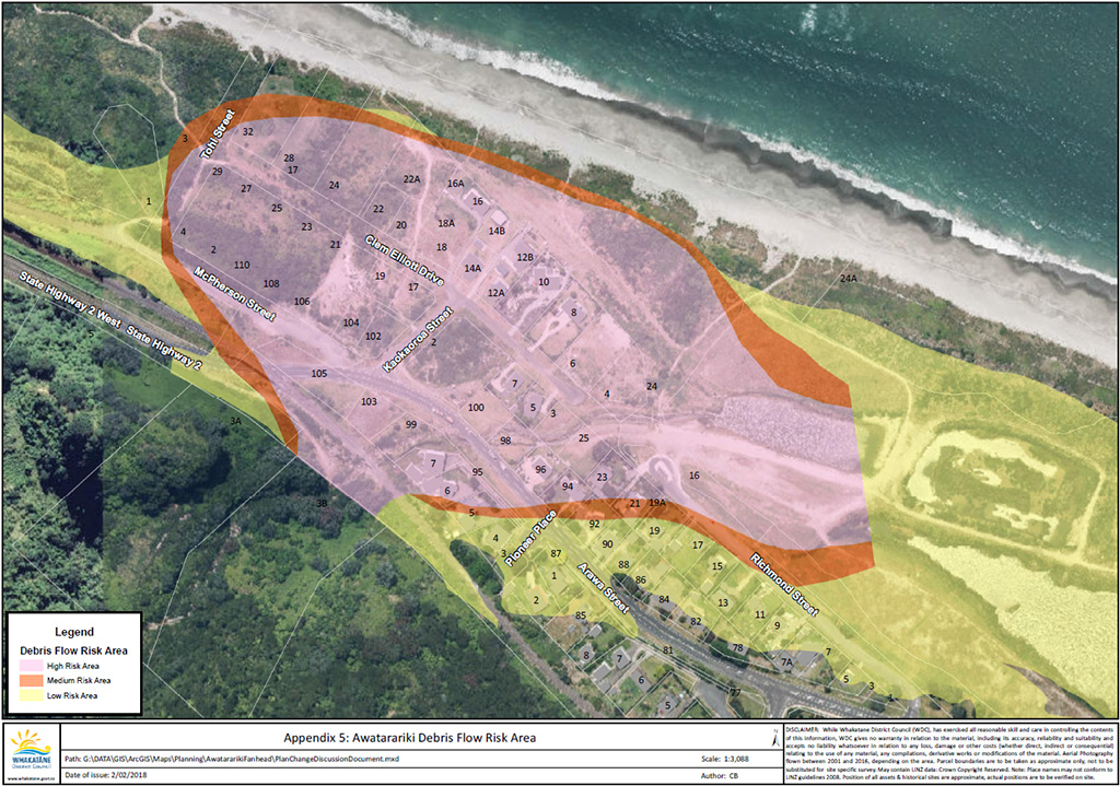
Q6 What properties are affected?
A6 The following map illustrates the extent of the high, medium and low debris flow risk areas in the coastal area directly below the Awatarariki Stream catchment.
Q7 Why these properties?
A7 The risk assessment process takes into account the areas which were badly impacted in the 2005 debris flow, the topography of the area, and modelling of how debris flows of differing magnitudes would behave. The risk assessments identified levels of risk which informed the areas designated as being high, medium, or low risk. Multiple peer reviews of the risk assessments have been undertaken by independent experts. The peer reviews all support the risk assessments. As noted above, the Council is obliged to seek plan changes to reduce a high or medium loss-of-life risk applying to all properties within these areas.
Q8 Who gets to have a say on the proposed plan changes?
A8 Everyone. The proposed plan changes are being publicly notified, which means that any person or organisation in New Zealand can make a submission in support or opposition of the proposals.
Q9 Who makes the decisions?
A9 All of the submissions received will be considered by qualified and experienced independent commissioners. The commissioners will weigh all of the evidence provided and make decisions on whether to accept or reject the submissions and make any consequential alterations to the plan changes. Those decisions can then be appealed to the Environment Court.
Managed retreat
Q10 What does the managed retreat involve?
A10 Council elected members approved the development of a managed retreat proposal, which aims to provide an opportunity for fanhead property owners to sell their properties at market value, as if the debris flow risk did not exist (i.e. at the market value which would apply in other, similar coastal subdivisions in the region). An independent peer-reviewed valuation process was undertaken to obtain indicative values for each property. The valuations were shared with the affected property owners. A crucial prerequisite to a managed retreat is gaining funding support from the Government and the Bay of Plenty Regional Council, because the likely cost of $15 million is unaffordable for Whakatāne District ratepayers. The managed retreat proposal also includes contributions towards legal and relocation costs.
Q11 Will property owners be bought-out?
A11 While there is no legal requirement to buy-out property owners, the Whakatāne District Council has prepared a business case to seek funding support for a managed retreat proposal. The managed retreat proposal incorporates a buy-out process. The business case is now being assessed by the Government and has also been presented to the Regional Council. If funding support is forthcoming, all private property owners in the high and medium risk areas on the fanhead will have the option of selling their properties and purchasing homes or land elsewhere. WDC has not set aside funding in its 2018-28 Long Term Plan for the managed retreat, but will include that funding requirement in an Annual Plan (and public consultation) process once Government funding has been confirmed.
Q12 Does the managed retreat apply to sections as well as properties with houses?
A12 The Council’s Acquisition Strategy is that all privately owned properties will be eligible for inclusion in a managed retreat process.
Q13 How long will retreat packages be available?
A13 A decision on the timeframe for acceptance will be made once funding has been confirmed. Once funding commitments are received, the property valuation process will be repeated and offers to purchase made based on current market value at that time. Any property owner who does not agree with the valuation will have an opportunity to seek a further valuation and engage in a mediation process.
Q14 Has a similar managed retreat been used successfully anywhere else?
A14 Retreat from natural hazards has occurred in New Zealand in the past. Examples include: Little Waihī village at the southern end of Lake Taupō, a small community on the west side of the Waiho River at Franz Josef, Aoraki Mount Cook village, and more recently, properties in the ‘red zone’ and Port Hills areas deemed to be inhabitable or unsafe to occupy following the Christchurch earthquakes.
The Risk
Q15 What is the risk to people and properties?
A15 The risk to residents’ lives from a future debris flow is much greater than is acceptable by international standards. Debris flow hazard and risk analyses indicate an annual loss-of-life risk for people residing in the fanhead area of between 1-in-100 and 1-in-1,000,000. The high risk area is that part of the fanhead which has an annual loss-of-life risk between 1-in-100 and 1-in-10,000. That loss-of-life risk is considerably higher than Christchurch Port Hills residents faced from landslides and boulder-roll and is much higher than internationally recognised levels of ‘tolerable risk’ (typically, these involve an annual loss-of-life risk of between 1-in-100,000 and 1-in-1,000,000). In 2016, the Ministry of Business, Innovation and Employment determined that the life safety risk was unacceptable and confirmed that building consents should not be issued for dwellings in the high-risk area.
Q16 Why can’t property owners decide whether they will accept the risk?
A16 The Resource Management Act (RMA) does not provide a mechanism for individual property owners to elect to accept high natural hazard risks. Changes to the RMA which came into effect in 2017 require local authorities to recognise that management of natural hazard risk is a matter of national importance. Territorial authorities manage natural hazard risks through District Plan provisions around zoning and subdivision and land-use applications. The RMA also requires regional councils to manage natural hazard risk through regional policy statements and plans. The Bay of Plenty Regional Policy Statement natural hazard provisions require high and medium risk to be reduced to low, where possible, and specifically recognise the responsibilities applying to ‘existing uses’ exposed to high levels of natural hazard risk. As the responsible authority, Whakatāne District Council is therefore obliged to seek to have the risk applying to residents of the Awatarariki fanhead reduced, and the only way to achieve that is by a managed retreat from the area.
Q17 What about the risk to rail and road users?
A17 The risk applying to the rail line and SH2 (both of which lie between the escarpment and the residential area of the fanhead) is recognised. The asset owners (NZTA and KiwiRail) have statutory responsibilities for users of their assets. Both organisations have been provided with the risk assessments.
Q18 Is there a compromise option, such as using land for camping?
A18 The only option which eliminates risk in the fanhead area is to cease all residential use and change the zoning of the area to coastal reserve, or similar. This would allow recreational use, but not residential use (including camping).
Where to from here?
Q19 What is the plan change process and what is the likely timeframe?
A19 The proposed plan changes will be publicly notified on 19 June 2018 with a 90-day submission period provided. This will allow any individual or organisation with an interest in this matter to make submissions and present evidence in support of, or in opposition to the proposals. All submissions and evidence will then be heard by expert, independent commissioners, who will decide on the submissions and whether the plan changes are to be altered. Submissions will close on 17 September 2018 and hearings are likely to be scheduled for April 2019, with decisions then following on within six to eight weeks. There will then be an appeal period, a mediation process for any appeals lodged and, if necessary, an Environment Court hearing.
Q20 What’s going to happen to the land if the plan changes go through?
A20 Whakatāne District Council’s proposal is that the land which becomes available through a managed retreat process will be deed-restricted, so that it cannot be built on in the future, and would become a coastal reserve area.
Q21 Can people sell their properties now?
A21 Properties can be sold on the open market at any time. However the hazard information registered on Land Information Memoranda would probably affect property values. Note that the managed retreat process specifically excludes new or recent purchasers profiting from the higher values which would result from valuations which ignore the debris flow hazard.
Q22 The boulders on the fanhead are the first things that people see when they come into Matatā from the west. When is the Council going to clean up this mess?
A22 Once this area becomes a reserve, it would be redeveloped to create an attractive coastal reserve space for community and public use.
Q23 When will zoning changes take effect?
A23 That will depend on the hearing process. The proposed District Plan change, which affects the zoning, will come into force when the change is made operative, after decisions on submissions and the resolution of any appeals to the Environment Court. The proposed regional rule, which makes residential activity a prohibited activity, states that it has effect from 31 March 2021; this is subject to the submission and hearing process.
Q24 When will people be expected to leave their properties?
A24 This could occur at any time, subject to: the plan changes being made operative; a managed retreat process and Government funding being finalised; and to a successful valuation and negotiation of a sale and purchase agreement for each property. As noted above, the proposed regional plan change stipulates a date for all residential properties to be vacated; this date may be changed through the submission and hearing process.
What about other areas with natural hazards?
Q25 What about other natural hazards, like landslides at Ōhope, tsunami and sea level rise?
A25 Debris flows differ significantly from landslides in terms of the scale, impact and the feasibility of mitigating the risk they represent. Landslide loss-of-life risks can be mitigated by structural means and in many instances, the owners of properties where a high landslide risk has been identified have already undertaken work to protect their properties. Landslide risks are registered on property land information memoranda and any building or land use consent process relating to high and medium risk properties will require that mitigation works be undertaken. Tsunami and sea level rise will undoubtedly affect many coastal areas around New Zealand. Where a risk of inundation has been identified, this is registered on Land information Memoranda. Sea level rise on its own is unlikely to represent a significant loss-of-life risk, because hazardous storms likely to cause inundation can be predicted with sufficient time to allow impacted areas to be evacuated. While retreat from sea level rise-related inundation may be required in future, there may, in some instances, be opportunities for Government and local government-initiated mitigation works to be considered.
Q26 What about the debris flow risk from other catchments in Matatā?
A26 Debris flows are a known hazard applying to a number of catchments in and to the west of Matatā. However, the size and nature of the Awatarariki catchment, the proximity or the residential area to the discharge point from the catchment, and the unavailability of any effective engineering solutions to mitigate the hazard, make this situation unique. For the next largest catchment in the urban area, the Waitepuru Stream, engineering works have been undertaken to divert any future debris flows onto unoccupied rural land, mitigating the risk to the Matatā Primary School and to the residential properties, which were affected by the 2005 debris flow from this catchment.