An activity is a 'boundary activity' if:
- Resource consent is required due to the infringement of one or more ‘boundary rules’
- No other district rules are infringed
- The 'infringed boundary' is not a 'public boundary'
Boundary rules are ones that:
- State the distance between a structure and a property boundary (or boundaries), or
- State the dimensions of a structure in relation to its distance from a boundary
Examples: yard setbacks, recession planes (height in relation to boundary)
Councils must exempt 'boundary activities' from needing a resource consent if neighbour's approval is provided for properties which adjoin the boundary the rule relates to (infringed boundary).
Application forms
Apply online for consent for a Deemed to be Permitted Boundary Activity »
Downloadable PDFs are available as an alternative option below:
- Deemed permitted boundary activity application form - (PDF, 2.26 MB)
- Written approval - Owner of Infringed Boundary - (PDF, 754 KB)
10 working day process for Deemed to be Permitted Boundary Activity Application
The Ministry for the Environment flow chart on how the process works is available below:
Deemed to be Permitted Boundary Activity Application flow chart »
Examples where Boundary Owners Written Approval is required for a Deemed to be Permitted Boundary Activity Application
Key to diagrams below

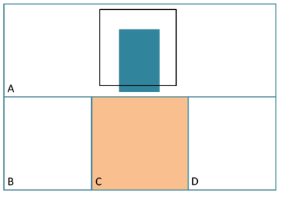
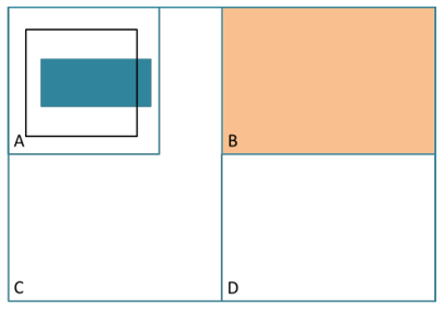
Directly infringed boundaries
The proposed structure in property A breaches the yard setback rule from boundary of allotment B.
Written approval is only required from the owner of B.
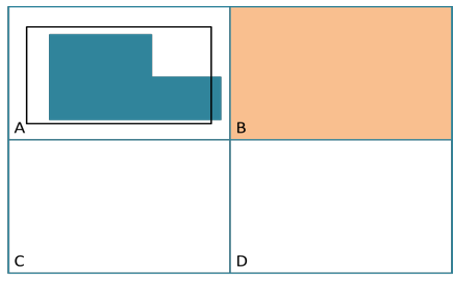
Corner sites
Example 1
The structure in property A infringes the yard setback rule applying to allotment B and C. It does not infringe the yard setback rule when measured from the corner.
Written approval is therefore required from the owners of B and C.
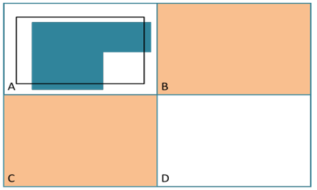
Example 2
The structure infringes the corner point of B, C, and D. Whether or not the District Plan is clear on whether an infringement can be measured from a corner point, allotment D is considered an infringed boundary under (b).
Written approval required from B, C & D
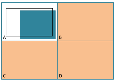
Private ways (legal Rights of Way, entrances strips or access lots)
The structure infringes a boundary that forms part of a ‘private way’. The approval of the owner of B is required, as the boundary on the opposite side of the private way is considered to be the infringed boundary, regardless of how the District Plan would normally apply.
Written approval of owner of B is required.
Site with multiple boundaries
As allotment C is the only boundary that is infringed by the structure in allotment A, C is the only allotment with an infringed boundary.
Written approval from owner of C only.